Cadair Idris: Height, Routes & Legend of Wales' Iconic Mountain
Key Takeaways
- Cadair Idris height is 893 metres (2,930 feet) at its summit, Pen y Gadair — one of the highest mountains in Wales. [Source: Ordnance Survey]
- Also spelled Cader Idris — Snowdonia National Park adopted this spelling on its official signage in 2016. Both spellings are correct and widely used.
- Located in southern Snowdonia (Eryri), Gwynedd, Wales, near the town of Dolgellau. Parking postcode for the Pony Path: LL40 1TN.
- Three main routes up: the Pony Path (easiest), the Minffordd Path (most scenic, steeper), and Fox's Path (steepest). Cadair Idris difficulty is moderate on the standard route.
- Legend says anyone who spends a night alone on the mountain wakes either a poet or a madman — or does not wake at all.
- Part of the Welsh Three Peaks Challenge alongside Snowdon (1,085m) and Pen y Fan (886m).
About Cadair Idris
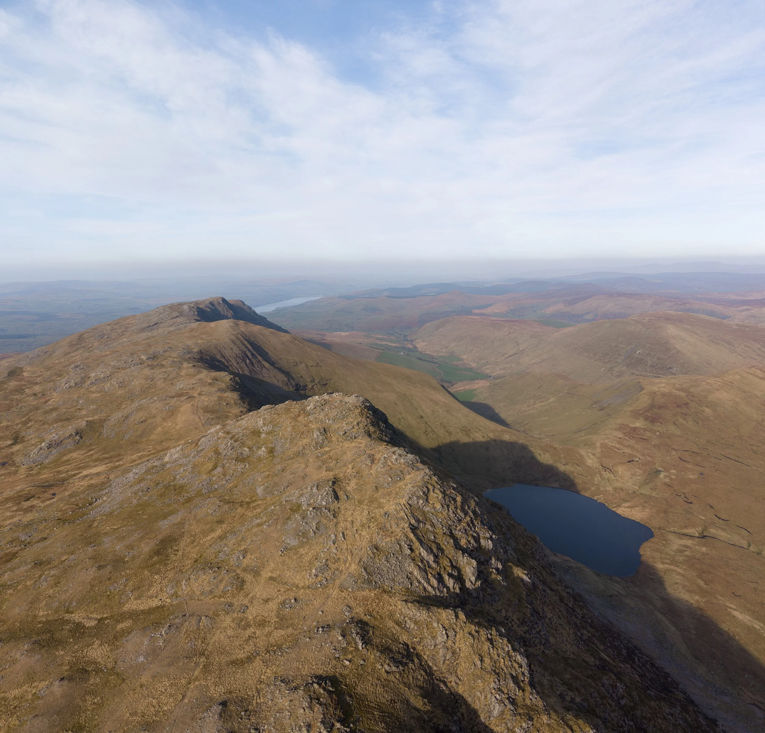
Cadair Idris is 893 metres (2,930 feet) high — one of the most iconic mountains in Wales and the second most climbed peak in Snowdonia National Park after Snowdon. Also known as Cader Idris, it sits at the southern end of the Snowdonia range in Gwynedd, overlooking the Mawddach Estuary and the market town of Dolgellau. Its summit, Pen y Gadair, offers sweeping views across Cardigan Bay to the Llŷn Peninsula on a clear day. The name Cadair Idris translates from Welsh as "the chair of Idris," referring to a legendary giant said to have used the summit as his throne.
Wales Cader Idris is lower than Snowdon (1,085m) by 192m, but many hillwalkers regard it as a wilder, quieter, and in some ways more rewarding climb. The mountain's horseshoe of cliffs above Llyn Cau is one of the most dramatic geological features in southern Snowdonia, and on a clear day the summit offers views from the Llŷn Peninsula to the Preseli Hills in Pembrokeshire — and even the Wicklow Mountains in Ireland.
Cadair Idris is the 19th-highest mountain in Wales, but its cultural footprint is far larger than that ranking suggests. It has inspired poets, painters, and storytellers for centuries — from the 18th-century landscape painter Richard Wilson to J.M.W. Turner, who sketched the mountain in 1798. The mountain remains a fixture of Welsh-language poetry and local folklore to this day.
Height & Prominence of Cadair Idris
Cadair Idris stands at 893 metres (2930 feet) above sea level, according to Ordnance Survey data. Its topographic prominence is 608 metres, meaning it rises at least that far above the col connecting it to the nearest higher peak. Cadair Idris is part of the Cadair Idris range, Snowdonia. The OS grid reference is SH 711 130, which you can use to locate the summit on any Ordnance Survey Explorer or Landranger map.
Cadair Idris carries the classifications of Hewitt, Nuttall, Marilyn.
Location & Nearest Towns
Cadair Idris is located in Wales, Gwynedd, within Snowdonia National Park. It sits in the Southern Snowdonia (Meirionnydd) area. The nearest towns and villages include Dolgellau, Llyn Cau, Minffordd, and others, where you can find accommodation, pubs, and supplies before or after your walk.
For sat-nav, use postcode LL40 1TN to reach the main parking area.
For official access information and any seasonal restrictions, check the Snowdonia National Park authority.
Interesting Facts
- Cadair Idris means "Chair of Idris" in Welsh — named after a giant from Welsh mythology
- Legend says anyone who spends a night alone on the mountain wakes either a poet or a madman — or does not wake at all
- The Cader Idris spelling was adopted on Snowdonia National Park signage in 2016, though both spellings are widely used
- Has three main walking routes: the Pony Path, the Minffordd Path, and the Fox's Path from Dol Idris
- Popular with Victorian tourists and artists, including J.M.W. Turner who painted the mountain in 1798
- Home to rare arctic-alpine plants including the Snowdon lily and purple saxifrage
- The summit, Pen y Gadair, sits at the head of a dramatic horseshoe of cliffs above Llyn Cau
- Cadair Idris is part of the Welsh Three Peaks Challenge alongside Snowdon and Pen y Fan
Walking Guide
The Pony Path from Ty Nant is the most popular and easiest route up Cadair Idris, one of the finest mountains in Snowdonia National Park. It starts from the Ty Nant car park (LL40 1TN) near Dolgellau and follows a well-graded path northwards through bracken and oak woodland before emerging onto open hillside. The trail climbs steadily to a broad ridge, then turns west to reach Pen y Gadair, the 893m summit, in roughly 3–4 hours. The round trip is about 9km and takes 5–6 hours. Cadair Idris difficulty on the Pony Path is moderate — no scrambling is required, and the gradient is the gentlest of the three main routes. The Minffordd Path from the south is shorter but steeper, climbing alongside Llyn Cau before a short scramble to the summit — arguably the most scenic route, with dramatic views of the glacial corrie and Llyn Cau far below. The Minffordd Path is the route most experienced walkers prefer for its drama and scenery, though the Cadair Idris difficulty is higher than the Pony Path due to steeper terrain and a short rocky section near the top. Fox's Path is the steepest and most direct, with loose scree near the summit; it should be ascended rather than descended. All three routes reward you with panoramic views across Cardigan Bay to the Llŷn Peninsula, and on a clear day you can see the Preseli Hills in Pembrokeshire and the Wicklow Mountains in Ireland. Check the Met Office mountain forecast before setting out, as Cadair Idris catches weather from both the Irish Sea and the interior of Snowdonia.
Hiking Routes
Choose a route based on your experience and fitness level.
Pony Path (from Ty Nant)
ModerateThe most straightforward route up Cadair Idris, with no scrambling and the gentlest gradient of the three main paths. Well-defined path with steps in the steeper sections.
Snow and ice can linger on the upper path into spring; winter mountaineering skills recommended when the summit is white.
Minffordd Path
HardThe most dramatic route, climbing past Llyn Cau in Cwm Cau before a steep pull to the ridge. Widely rated the finest way up the mountain, and extendable into a circuit over Mynydd Moel. Rugged, strenuous walking with sustained ascent.
Cwm Cau's headwall and the final ridge approach require full winter kit in snow and ice conditions.
Fox's Path
HardThe shortest and steepest option, notorious for a long, loose scree section on the final approach to the summit. Best avoided as a descent route — most walkers descend via the Pony Path instead.
How Tall Is Cadair Idris? (Height in Metres and Feet)
The height of Cadair Idris is 893 metres (2,930 feet) above sea level, according to Ordnance Survey data. The summit is known as Pen y Gadair — Welsh for "the head of the chair" — and sits at the head of a dramatic horseshoe of cliffs enclosing Llyn Cau, a glacial lake formed during the last ice age.
To put the Cadair Idris height in context, here is how it compares to the other mountains in the Welsh Three Peaks Challenge:
| Peak | Region | Height (metres) | Height (feet) |
|---|---|---|---|
| Snowdon / Yr Wyddfa | North Snowdonia | 1,085m | 3,560ft |
| Cadair Idris | South Snowdonia | 893m | 2,930ft |
| Pen y Fan | Brecon Beacons | 886m | 2,907ft |
At 893m, Cadair Idris is only 7m taller than Pen y Fan — a remarkably small gap for mountains 90 miles apart. The Cader Idris height makes it a Marilyn (a peak with 150m+ of topographic prominence), with a prominence of 608m — one of the highest in Wales. It is also classified as a Hewitt and a Nuttall. [Source: Ordnance Survey]
Cadair Idris vs Cader Idris — Why Two Spellings?
Both "Cadair Idris" and "Cader Idris" are correct and widely used. The difference comes down to Welsh orthography versus local dialect.
Cadair Idris is the standard literary Welsh spelling, used in most modern maps, guidebooks, and official documents. The word "cadair" means "chair" in Welsh.
Cader Idris reflects the local Meirionnydd dialect pronunciation, where the final consonant softens. This spelling has been used informally for centuries and appears in many historical references. In 2016, Snowdonia National Park adopted the "Cader Idris" spelling on its official signage — a decision that acknowledged the local dialect while causing some debate among Welsh-language purists.
In practice, you will see both spellings on maps, road signs, and guidebooks throughout the region. The mountain is the same regardless of which spelling you use, and both terms are searched for extensively online — "Cader Idris" is particularly common in older guidebooks and in English-language walking literature.
For reference, the mountain's Welsh name on Ordnance Survey maps is "Cadair Idris," while the summit itself is labelled "Pen y Gadair" — "the head of the chair."
How Difficult Is Cadair Idris to Climb?
Cadair Idris difficulty is rated moderate on the standard Pony Path — it is a accessible walk for anyone with a reasonable level of fitness, with no scrambling required and a well-graded path throughout. However, the difficulty increases significantly on the alternative routes.
Here is a breakdown of Cadair Idris difficulty by route:
| Route | Difficulty | Distance | Ascent | Time |
|---|---|---|---|---|
| Pony Path (Ty Nant) | Moderate | ~9 km | ~720m | 5–6 hrs |
| Minffordd Path | Moderate–Hard | ~6 km | ~730m | 5–6 hrs |
| Fox's Path (Dol Idris) | Hard | ~7 km | ~750m | 5–7 hrs |
The Pony Path is the route most walkers choose for their first Cadair Idris climb. It has the gentlest gradient, a well-built stone path, and no scrambling. The Minffordd Path is shorter but steeper, with a short scramble near the summit — it is the most scenic route, passing Llyn Cau and skirting the dramatic cliffs of the horseshoe. Fox's Path is the steepest and most direct, with loose scree near the summit that can be treacherous on descent; it should be ascended rather than descended.
In winter conditions (December–March), Cadair Idris difficulty increases substantially. Ice and snow on the upper slopes can make the Pony Path treacherous, and the Minffordd scramble becomes a genuine mountaineering challenge. Always check the Met Office mountain forecast and carry ice axe and crampons if there is any chance of winter conditions.
Cadair Idris Routes: Pony Path, Minffordd and Dol Idris
There are three main Cadair Idris routes, each starting from a different trailhead and offering a distinct experience:
1. The Pony Path (from Ty Nant) — the most popular and easiest route. It starts from the Ty Nant car park (postcode LL40 1TN) near Dolgellau and follows a well-graded stone path northwards through bracken and oak woodland before emerging onto open hillside. The trail climbs steadily to a broad ridge, then turns west to reach Pen y Gadair. The round trip is about 9km with 720m of ascent, taking 5–6 hours. This is the route we recommend for first-time visitors and families.
2. The Minffordd Path (from the south) — shorter but steeper, and widely regarded as the most scenic route up Cadair Idris. It starts from the Minffordd car park on the A487 and climbs alongside the stunning Llyn Cau before a short scramble to the summit. The dramatic views of the glacial corrie and Llyn Cau far below are among the finest in southern Snowdonia. The round trip is approximately 6km with 730m of ascent, taking 5–6 hours.
3. Fox's Path / Dol Idris route — the steepest and most direct route, starting from the Dol Idris car park on the northern side of the mountain. It involves loose scree near the summit and should be ascended rather than descended. The round trip is about 7km with 750m of ascent, taking 5–7 hours. This route is best suited to experienced walkers who are confident on steep, loose ground.
For a complete Cadair Idris route map, we recommend carrying OS Explorer OL18 (Cadair Idris & Llyn Peninsula) or the Harvey Cadair Idris Superwalker map. Both show all three routes plus the surrounding paths and tracks in clear detail.
The Legend of Cadair Idris: The Giant's Chair
Cadair Idris — "the Chair of Idris" — takes its name from a giant of Welsh folklore. According to legend, Idris was a giant who lived in the area and used the mountain's summit as his chair, from which he could survey his domain. The name "Pen y Gadair" — "the head of the chair" — refers specifically to the summit.
The mountain is steeped in Welsh mythology. The most famous legend holds that anyone who spends a night alone on the slopes of Cadair Idris will wake up either a poet, a madman, or not wake at all. This tale has drawn romantics, poets, and adventurers to the mountain for centuries, and it remains one of the best-known pieces of Welsh mountain folklore.
The lake near the summit, Llyn Cau, is also woven into the legend. Some versions of the tale say Idris used the lake as a bath; others that the giant's chair overlooked it. The lake sits in a dramatic glacial corrie at the head of the horseshoe and is one of the most striking features of the mountain — many walkers on the Minffordd Path pause here before the final push to the summit.
The Idris legend has inspired Welsh-language poetry for centuries and was a favourite subject of Romantic-era painters. Richard Wilson, the 18th-century Welsh landscape painter, depicted Cadair Idris in several works, and J.M.W. Turner sketched the mountain during his tour of Wales in 1798. The mountain remains a powerful symbol in Welsh cultural identity — a wild place where the boundary between inspiration and madness feels thin.
Visiting Cadair Idris: Parking, Nearest Towns & Practical Info
If you are planning to climb Cadair Idris, here is the practical information you need:
Parking: The Pony Path starts from the Ty Nant car park (postcode LL40 1TN), about 4 miles from Dolgellau. The Minffordd Path starts from the Minffordd car park on the A487. The Fox's Path / Dol Idris route starts from the Dol Idris car park. All three car parks are signposted from the main roads, but the Ty Nant car park can fill up quickly on summer weekends — arrive before 9am to guarantee a space.
Nearest town: Dolgellau is the main base for Cadair Idris, with a full range of accommodation, pubs, cafes, and outdoor shops. It is approximately 4 miles from the Ty Nant trailhead. Barmouth and Tywyn are also within easy reach on the coast.
OS map: Ordnance Survey Explorer OL18 (Cadair Idris & Llyn Peninsula) covers all three routes. The OS grid reference for the summit is SH 711 130.
Best time to visit: May to September offers the most reliable conditions, with the longest daylight and the least chance of ice on the upper slopes. October and April are shoulder season — expect changeable weather. From November to March, the mountain can be a serious winter proposition, particularly on the Minffordd scramble and Fox's Path.
Public transport: The Ty Nant and Minffordd trailheads are accessible by bus from Dolgellau, but services are limited — check the Snowdonia National Park website for current timetables. The nearest railway station is at Barmouth, about 12 miles away.
Cadair Idris vs Snowdon: Which Should You Climb?
Cadair Idris and Snowdon (Yr Wyddfa) are the two most popular mountains in Snowdonia National Park, and walkers often ask which one to choose. The answer depends on what you are looking for.
Height: Snowdon is 192m taller (1,085m vs 893m) and is the highest mountain in Wales. If your goal is to stand on the highest point in Wales, Snowdon is the one.
Crowds: Snowdon attracts over 500,000 visitors a year and can be very busy on summer weekends, particularly on the Llanberis Path and the Pyg Track. Cadair Idris receives far fewer walkers — even on a fine summer day, you can have large sections of the Pony Path to yourself.
Wildness: Many experienced hillwalkers consider Cadair Idris the wilder and more atmospheric mountain. Its horseshoe of cliffs above Llyn Cau, its rich folklore, and its relative quiet give it a sense of remoteness that Snowdon — with its summit cafe, railway, and well-trodden paths — can lack.
Difficulty: Both mountains have moderate standard routes. The Snowdon Llanberis Path and the Cadair Idris Pony Path are both accessible to fit walkers without scrambling. However, both mountains also have harder routes — the Snowdon Watkin Path and Crib Goch are more technically demanding than anything on Cadair Idris.
Access: Snowdon has better public transport (the Sherpa bus network and the Snowdon Mountain Railway), while Cadair Idris is more dependent on a car.
If you have time, climb both — they are very different experiences and together they give a full picture of what Snowdonia has to offer. Browse our UK mountains directory to discover more peaks in Wales and beyond.
Safety Tips
Always check forecasts before setting out. Summit conditions differ dramatically from valley level.
Carry map, compass/GPS, water, food, first aid, whistle, torch, and waterproofs.
Tell someone your route and return time. Stick to marked paths. Be ready to turn back.
Ask for Police, then Mountain Rescue. Know your grid reference.
On the Mountain: Walking Cadair Idris
Cadair Idris is a moderate walk that rewards careful planning. The summit sits at 893m, where conditions can feel distinctly different from the valley — wind speeds are typically 30–50% stronger above 800m, and the temperature drops roughly 1°C for every 100m of ascent. In cloud, the cairn at the top can be hard to spot, so keep a map and compass to hand even on well-marked paths.
After your walk, the nearest village — Dolgellau — is a good place for a pint and a debrief. For detailed route descriptions and trip reports from other walkers, Walkhighlands is an excellent resource.
Nearby Dining
- Tynycornel Hotel
- The George III Hotel
- Dolgellau Cafe
Frequently Asked Questions
Is Cadair Idris one of the best mountains to climb in the UK?
Yes, Cadair Idris is considered one of the best mountains to climb in the UK thanks to its scenic routes, 893m elevation, and moderate difficulty level.
What difficulty level is Cadair Idris?
Cadair Idris has a difficulty rating of Moderate. There are 3 documented routes to choose from.
When is the best time to climb Cadair Idris?
The best season is May to September. Summit temperatures are typically 5–10°C colder than the valley, and conditions can change rapidly.
Where should I park for Cadair Idris?
Use postcode LL40 1TN for sat-nav. Arrive early on weekends — car parks fill quickly during peak season.
How tall is Cadair Idris?
Cadair Idris is 893 metres (2,930 feet) high at its summit, Pen y Gadair, according to Ordnance Survey data. This makes it one of the highest mountains in Wales, though it is 192m lower than Snowdon (1,085m).
What is the height of Cadair Idris in feet?
The height of Cadair Idris is 2,930 feet (893 metres) above sea level. The Cader Idris height is the same regardless of which spelling you use — both refer to the same mountain.
Is it Cadair Idris or Cader Idris?
Both are correct. Cadair is the standard Welsh spelling; Cader reflects the local Meirionnydd dialect and is also used on Snowdonia National Park signage, which adopted the Cader Idris spelling officially in 2016.
How tall is Mount Cader Idris?
Mount Cader Idris reaches 893m (2,930 ft) at its highest summit, Pen y Gadair. It is the 19th-highest mountain in Wales but one of the two most popular after Snowdon.
How difficult is Cadair Idris to climb?
Cadair Idris difficulty is rated moderate on the standard Pony Path — no scrambling is required and the gradient is gradual. The Minffordd Path is steeper with a short scramble near the summit, and Fox's Path is the most challenging with loose scree. A reasonable level of fitness is needed for all routes.
Is Cadair Idris part of the Welsh Three Peaks Challenge?
Yes — it's commonly climbed as part of the Welsh Three Peaks Challenge alongside Snowdon (Yr Wyddfa, 1,085m) and Pen y Fan (886m) in the Brecon Beacons.
How long does it take to climb Cadair Idris?
The Pony Path round trip takes 5–6 hours for fit walkers, covering roughly 9km with 720m of ascent. The Minffordd Path is similar in time but shorter in distance with steeper terrain.
Which is the easiest route up Cadair Idris?
The Pony Path from Ty Nant is the easiest of the three main routes — it has no scrambling, a steadier gradient, and is the standard choice for most walkers. The Minffordd Path is more scenic but harder, and Fox's Path is the steepest and should generally be climbed, not descended, because of loose scree near the summit.
Where is Cadair Idris?
Cadair Idris is in Gwynedd, Wales, at the southern end of Snowdonia National Park (Eryri). The nearest town is Dolgellau, and the parking postcode for the Pony Path trailhead at Ty Nant is LL40 1TN.
Is Cadair Idris higher than Snowdon?
No. Snowdon (Yr Wyddfa) at 1,085m is 192m higher than Cadair Idris at 893m. However, many hillwalkers consider Cadair Idris a wilder and more rewarding climb due to its dramatic cliffs, quieter paths, and rich folklore.
Why Visit Cadair Idris?
Cadair Idris stands at 893m (2930ft) in Wales, Gwynedd. Classified as a Hewitt and Nuttall and Marilyn, it is a rewarding destination for hikers, climbers, and photographers. Known for the legend that sleeping on its summit makes you a poet or a madman.
Browse our UK mountains directory to discover more peaks, or see all mountains A–Z.
Nearby Peaks to Explore
Looking beyond Cadair Idris? These peaks are close by and worth exploring.