Ben Nevis Mountain: The UK's Highest Peak
Key Takeaways
- Ben Nevis mountain is 1,345 metres (4,413 feet) high — the highest mountain in the UK, Scotland, and the British Isles. [Source: Ordnance Survey]
- It sits in the Grampian Mountains near Fort William in Lochaber, Highland, Scotland — postcode PH33 6ST for the Glen Nevis car park.
- The Ben Nevis Mountain Track (also called the Pony Track or Tourist Path) is the standard route: ~17km round trip, 7–9 hours, roughly 1,345m of elevation gain.
- It forms part of the National Three Peaks Challenge alongside Snowdon (1,085m) and Scafell Pike (978m), and is 36m taller than the UK's second-highest peak, Ben Macdui (1,309m).
About Ben Nevis
Ben Nevis mountain is 1,345 metres (4,413 feet) tall — the highest mountain in the UK and the British Isles. Located in Lochaber, Highland, Scotland near Fort William, it attracts 130,000–150,000 walkers each year and is the most climbed peak in the country.
Ben Nevis mountain draws over 150,000 walkers a year, more than any other Scottish mountain, which makes route choice and timing more important here than on quieter peaks — the Ben Nevis Mountain Track can be genuinely congested on a clear summer weekend. In practice, the busiest window is 10am–2pm on the lower half of the Mountain Track; setting off before 8am avoids most of the crowding and gives more daylight buffer for the descent.
Underestimating the summit plateau in poor visibility is a common mistake — the flat, featureless top has claimed lives from walkers who wandered off-path near Five Finger Gully in cloud. Even on the "Moderate" tourist route, a map, compass (or reliable GPS), and the confidence to use them are not optional extras.
What type of mountain is Ben Nevis? Geologically, the summit sits on the collapsed dome of an ancient Devonian volcano. The dramatic north face cliffs — up to 600m high — are the eroded remains of that volcanic structure, making Ben Nevis a volcanic mountain rather than a folded sedimentary peak. This geology also explains why the north face is one of the most important winter climbing venues in the UK, with classic routes like Point Five Gully and Zero Gully attracting climbers from across the world.
Ben Nevis is sometimes confused with Ben Wyvis, a separate 1,046m mountain in the northern Highlands near Dingwall. The two are entirely different peaks — Ben Wyvis is a Corbett roughly 40 miles north-east of Fort William, while mountain Ben Nevis is the UK's highest summit at 1,345m in Lochaber. If you're planning a trip, make sure your map, accommodation and route guide refer to the right one.
Height & Prominence of Ben Nevis
Ben Nevis stands at 1345 metres (4413 feet) above sea level, according to Ordnance Survey data. Its topographic prominence is 1345 metres, meaning it rises at least that far above the col connecting it to the nearest higher peak. Ben Nevis is part of the Grampian Mountains. The OS grid reference is NN 166 712, which you can use to locate the summit on any Ordnance Survey Explorer or Landranger map.
Ben Nevis carries the classifications of Munro, Marilyn. As a Munro, it is one of Scotland's 282 summits over 3,000 ft (914.4 m), as originally catalogued by Sir Hugh Munro in 1891.
Location & Nearest Towns
Ben Nevis is located in Scotland, Highland, within Lochaber Geopark. It sits in the Grampian Mountains area. The nearest towns and villages include Fort William (7 miles), Glen Nevis, Steall Falls, and others, where you can find accommodation, pubs, and supplies before or after your walk.
For sat-nav, use postcode PH33 6ST to reach the main parking area.
For official access information and any seasonal restrictions, check the Lochaber Geopark authority.

Interesting Facts
- Ben Nevis is the highest mountain in the UK and the British Isles at 1,345 metres
- The summit plateau is the collapsed dome of an ancient volcano — Ben Nevis is a volcanic mountain
- Snow can remain on the mountain year-round in sheltered gullies on the north face
- The Ben Nevis Race has been held annually since 1895 — the record is under 1 hour 25 minutes
- The first car was driven to the summit in 1911, a Model Ford that took three days
- The summit hosted a continuously staffed weather observatory from 1883 to 1904 — its ruins remain today
- Ben Nevis is classified as both a Munro and a Marilyn, reflecting its height and prominence
Walking Guide
The Ben Nevis Mountain Track (also called the Pony Track or Tourist Path) is the route most visitors take to the summit of Ben Nevis, the highest mountain in the UK. It begins at the Glen Nevis visitor centre car park (postcode PH33 6ST) and follows a clear stone path up the western slopes, passing the Halfway Lochan and the old observatory ruins before reaching the 1,345m summit cairn. The round trip is approximately 10.5 miles (17km) with roughly 1,345m of elevation gain, and takes 7–9 hours for a fit walker. The path is well-built but relentless — about 1,300m of ascent over 6.5km each way. In summer the Ben Nevis Mountain Track is straightforward underfoot, but the summit plateau is notoriously featureless and dangerous in poor visibility: always carry a map and compass, and know how to take a bearing. OS Explorer 392 (Ben Nevis & Fort William) is the recommended Ben Nevis route map. The alternative CMD Arete route approaches from the north-east via the Carn Mor Dearg ridge and is one of the finest moderate scrambles in Scotland — grade 2-3 in summer conditions, but a serious winter climb from November to March. For the full experience, acclimatise in Glen Nevis the day before, start early to avoid afternoon clouds on the summit, and check the Met Office mountain forecast before setting out. A Ben Nevis tourist path map is available at the visitor centre.
Hiking Routes
Choose a route based on your experience and fitness level.
Mountain Track (Tourist Path)
ModerateThe most popular route up Ben Nevis, also known as the Pony Track. A well-maintained path that zigzags up the western side of the mountain.
Well-maintained path with good waymarking. Can be busy in summer. Watch for weather changes at the summit.
Winter: Requires winter mountaineering skills, ice axe and crampons essential. Summit plateau can be dangerous in poor visibility.
CMD Arête via Carn Mòr Dearg
HardA longer, more challenging route involving a spectacular narrow arête ridge. One of the finest ridge walks in the UK.
Involves scrambling and exposure on the arête. Not suitable for inexperienced walkers. Requires good head for heights.
Winter: Serious mountaineering route. Grade I/II winter climb. Full winter equipment and experience essential.
How High Is Ben Nevis in Metres and Feet?
Ben Nevis is 1,345 metres (4,413 feet) above sea level, according to Ordnance Survey data confirmed in 2016. This makes it the highest mountain in Scotland, the UK, and the British Isles. In Ben Nevis metres, the figure is 1,345m; in feet, 4,413ft — roughly 260m taller than Snowdon, the tallest peak in Wales.
To put that in context, here is how Ben Nevis compares to the other two mountains in the National Three Peaks Challenge:
| Peak | Country | Height (metres) | Height (feet) |
|---|---|---|---|
| Ben Nevis | Scotland | 1,345m | 4,413ft |
| Snowdon / Yr Wyddfa | Wales | 1,085m | 3,560ft |
| Scafell Pike | England | 978m | 3,209ft |
Ben Nevis is 36m taller than the UK's second-highest peak, Ben Macdui (1,309m) in the Cairngorms. The Ben Nevis elevation gain on the standard Mountain Track is roughly 1,345m — you climb the full height of the mountain from the Glen Nevis car park to the summit. [Source: Ordnance Survey]
Where Is Ben Nevis?
Ben Nevis is in Lochaber, Highland, Scotland, close to the town of Fort William. What country is Ben Nevis in? It is in Scotland, within the United Kingdom. The mountain sits at the western end of the Grampian Mountains, overlooking Glen Nevis to the south and Loch Eil to the north.
The OS grid reference for the summit is NN 166 712. The nearest town is Fort William, roughly 5 miles from the summit, which serves as the main base for walkers climbing Ben Nevis. Fort William has a railway station, bus connections, and a full range of accommodation. The parking postcode for the Glen Nevis visitor centre car park is PH33 6ST.
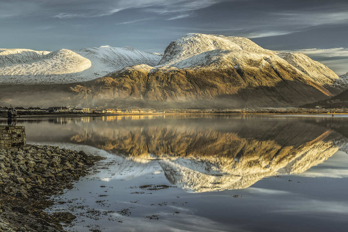
Ben Nevis is within the Lochaber Geopark, a UNESCO-recognised area of outstanding geological interest. The mountain's dramatic north face — with cliffs up to 600m high — is visible from Fort William and is one of the most iconic mountain landscapes in Scotland.
What Mountain Range Is Ben Nevis In?
Ben Nevis is part of the Grampian Mountains, the largest mountain range in Scotland. The Grampians stretch from the southwest Highlands through the central Highlands to the Cairngorms in the east, and include most of Scotland's highest peaks.
The Ben Nevis range of mountains specifically refers to a small cluster of peaks around Ben Nevis itself, including Carn Mor Dearg (1,220m), Carn Dearg Meadhonach (1,181m), and Aonach Beag (1,234m). These peaks form a horseshoe ridge around the north face of Ben Nevis, and the CMD Arete route connecting Carn Mor Dearg to Ben Nevis is widely regarded as one of the finest ridge walks in the UK.
So if you're asking which mountain range Ben Nevis is in, the answer is the Grampian Mountains — a broad range that also encompasses the Cairngorms, where Ben Macdui (1,309m) and Braeriach (1,296m), the UK's second and third highest peaks, are found.
Ben Nevis Routes and Track Map
There are two main Ben Nevis hiking routes that walkers use to reach the summit:
1. The Ben Nevis Mountain Track (Pony Track / Tourist Path) — the standard route for most walkers. It starts at the Glen Nevis visitor centre car park (postcode PH33 6ST), follows a well-built stone path up the western side of the mountain, and reaches the summit via the Halfway Lochan and the old observatory ruins. The round trip is about 10.5 miles (17km) with 1,345m of elevation gain, taking 7–9 hours for a fit walker. A Ben Nevis tourist path map is available at the visitor centre, and OS Explorer 392 covers the route in detail.
2. The CMD Arete (Carn Mor Dearg Arete) — a spectacular ridge walk approaching Ben Nevis from the north-east. It begins from the North Face car park, ascends Carn Mor Dearg (1,220m), and follows a narrow rocky arete to the summit of Ben Nevis. This route is longer and more exposed, requiring scrambling skills and a head for heights. It is one of the finest moderate mountain routes in Scotland.
For a Ben Nevis routes map, we recommend carrying OS Explorer 392 (Ben Nevis & Fort William) or Harvey's Ben Nevis Superwalker map. Both show the Mountain Track, CMD Arete, and the surrounding peaks in clear detail. Always check the Met Office mountain forecast before setting out, and carry a Ben Nevis route map even on clear days — the summit plateau is notoriously featureless in cloud.
Is Ben Nevis a Mountain?
Yes — Ben Nevis is unquestionably a mountain. At 1,345m (4,413ft) it far exceeds the 600m (2,000ft) threshold commonly used to distinguish mountains from hills in the UK, and it is classified as both a Munro (a Scottish peak over 3,000ft / 914m) and a Marilyn (a peak with 150m+ of topographic prominence).
What type of mountain is Ben Nevis? Geologically, Ben Nevis is the remains of an ancient volcano. The summit sits on the collapsed inner dome of a Devonian volcanic centre, and the dramatic north face cliffs are the eroded remains of the volcanic structure. This makes Ben Nevis a volcanic mountain, distinct from the folded sedimentary mountains found in parts of the Lake District and Wales.
The mountain is named from the Gaelic "Beinn Nibheis", often translated as "malicious mountain" or "mountain with its head in the clouds" — a fitting description given how frequently the summit is shrouded in mist.
Best Time to Climb Ben Nevis, Month by Month
May–September: most stable window, longest daylight, both routes at their stated grade without winter skills required.
October & April: shoulder season — expect some snow on the summit plateau even in a mild year; check current conditions before relying on the standard grade.
November–March: a genuine winter mountaineering objective. The CMD Arete in particular becomes a Grade I/II winter climb requiring ice axe, crampons, and the experience to use them.
Ben Nevis vs. Ben Wyvis — Quick Clarification
Ben Nevis and Ben Wyvis are two entirely different mountains. Ben Nevis (1,345m) is the UK's highest peak, near Fort William in the Lochaber Geopark. Ben Wyvis (1,046m) is a separate Munro roughly 70 miles north, near Dingwall in Easter Ross, known for its long whaleback ridge rather than any connection to Ben Nevis.
Safety Tips
Always check forecasts before setting out. Summit conditions differ dramatically from valley level.
Carry map, compass/GPS, water, food, first aid, whistle, torch, and waterproofs.
Tell someone your route and return time. Stick to marked paths. Be ready to turn back.
Ask for Police, then Mountain Rescue. Know your grid reference.
On the Mountain: Walking Ben Nevis
Ben Nevis is a moderate walk that rewards careful planning. The summit sits at 1345m, where conditions can feel distinctly different from the valley — wind speeds are typically 30–50% stronger above 800m, and the temperature drops roughly 1°C for every 100m of ascent. In cloud, the cairn at the top can be hard to spot, so keep a map and compass to hand even on well-marked paths.
After your walk, the nearest village — Fort William (7 miles) — is a good place for a pint and a debrief. For detailed route descriptions and trip reports from other walkers, Walkhighlands is an excellent resource.
Nearby Dining
- Ben Nevis Inn
- Glen Nevis Restaurant
- Nevisport Cafe
Frequently Asked Questions
Is Ben Nevis one of the best mountains to climb in the UK?
Yes, Ben Nevis is considered one of the best mountains to climb in the UK thanks to its scenic routes, 1345m elevation, and moderate difficulty level.
What difficulty level is Ben Nevis?
Ben Nevis has a difficulty rating of Moderate. There are 2 documented routes to choose from.
When is the best time to climb Ben Nevis?
The best season is May to September. Summit temperatures are typically 5–10°C colder than the valley, and conditions can change rapidly.
Where should I park for Ben Nevis?
Use postcode PH33 6ST for sat-nav. Arrive early on weekends — car parks fill quickly during peak season.
How high is Ben Nevis in metres?
Ben Nevis is 1,345 metres (4,413 feet) above sea level, according to Ordnance Survey data confirmed in 2016. This makes it the highest mountain in the UK, Scotland, and the British Isles.
What is the exact Ben Nevis height in feet?
Ben Nevis stands at 4,413 feet (1,345 metres) above sea level, making it the highest point in the UK and the British Isles.
Is Ben Nevis a mountain?
Yes, Ben Nevis is a mountain. At 1,345m it far exceeds the 600m (2,000ft) threshold used to distinguish mountains from hills in the UK. It is classified as a Munro (Scottish peak over 3,000ft/914m) and a Marilyn (150m+ prominence).
What country is Ben Nevis in?
Ben Nevis is in Scotland, within the United Kingdom. It is located in Lochaber, Highland, near the town of Fort William.
What mountain range is Ben Nevis in?
Ben Nevis is part of the Grampian Mountains, the largest mountain range in Scotland. The Grampians stretch from the southwest Highlands through the central Highlands to the Cairngorms in the east.
What type of mountain is Ben Nevis?
Ben Nevis is a volcanic mountain — the summit sits on the collapsed dome of an ancient Devonian volcano. The dramatic north face cliffs are the eroded remains of the volcanic structure, making it geologically distinct from folded sedimentary mountains.
Where is Ben Nevis?
Ben Nevis is in Lochaber, Highland, Scotland, close to Fort William. The OS grid reference is NN 166 712, and the parking postcode for the Glen Nevis visitor centre is PH33 6ST.
Is Ben Nevis the highest mountain in the whole UK, or just Scotland?
The whole UK. Ben Nevis is also the highest point in the British Isles overall, ahead of Ireland's Carrauntoohil (1,041m).
How does Ben Nevis compare to Ben Macdui?
Ben Nevis is 36m taller than Ben Macdui (1,309m), the UK's second-highest peak, located in the Cairngorms. Ben Nevis holds the title outright by a wide margin.
Is Ben Nevis the same mountain as Ben Wyvis?
No. They're separate Munros roughly 100 miles apart — Ben Nevis (1,345m) near Fort William is the UK's highest mountain, while Ben Wyvis (1,046m) near Dingwall in Easter Ross is a different, lower peak with no connection to Ben Nevis beyond sharing the Gaelic "Beinn" element in its name.
How long does it take to climb Ben Nevis?
The Ben Nevis Mountain Track takes 7–9 hours for a fit walker to complete the round trip of roughly 10.5 miles (17km) with 1,345m of elevation gain. Start early to avoid afternoon cloud and crowds.
When is the best time to climb Ben Nevis?
May to September offers the most stable conditions, longest daylight, and snow-free paths on the standard Mountain Track. From November to March, Ben Nevis is a genuine winter mountaineering objective requiring ice axe, crampons, and winter skills.
What is the Ben Nevis postcode for parking?
The postcode for the Glen Nevis visitor centre car park, the starting point for the Ben Nevis Mountain Track, is PH33 6ST. Arrive early on weekends as the car park fills quickly.
Why Visit Ben Nevis?
Ben Nevis stands at 1345m (4413ft) in Scotland, Highland. Classified as a Munro and Marilyn, it is a rewarding destination for hikers, climbers, and photographers. Known for being the highest mountain in the uk.
Browse our UK mountains directory to discover more peaks, or see all mountains A–Z.
Nearby Peaks to Explore
Looking beyond Ben Nevis? These peaks are close by and worth exploring.